
Outdoor Activities and Parks in Woodland Hills — A Complete Guide
Woodland Hills 91364 and 91367 sit at the edge of something that most Los Angeles residents drive 30–45 minutes to reach: 153,000 acres of protected wilderness. The Santa Monica Mountains National Recreation Area — the largest urban national park in the United States — begins at the western boundary of Woodland Hills's residential fabric. Topanga State Park, the largest state park within any American city, has trailheads accessible from specific 91364 residential streets by foot. The Backbone Trail, the Calabasas Peak summit, Malibu Creek State Park, and the Upper Las Virgenes Canyon Open Space Preserve are all within 5–20 minutes of most Woodland Hills addresses.
This is not the outdoor access that most SFV neighborhoods describe — a city park with a playground and a picnic table. This is wilderness. Chaparral-covered ridgelines with Pacific Ocean views on clear mornings. Native oak woodlands with wildlife that includes mountain lions, bobcats, mule deer, and over 450 bird species. Single-track mountain biking that draws riders from across Southern California. Equestrian trails that have been used for over a century. And the specific quality of outdoor immersion — the silence, the scale, the absence of urban infrastructure — that is genuinely rare within any American metropolitan area.
For residents who engage with it daily, this proximity transforms what the word "neighborhood" means. This guide maps every significant outdoor asset available from Woodland Hills, with the specific access points, trail lengths and difficulties, seasonal considerations, and practical logistics that make the difference between knowing the resource exists and actually building it into your daily life.
1. 🏔️ Topanga State Park — The Wilderness at Woodland Hills's Door
Topanga State Park is the outdoor asset that most consistently exceeds visitor expectations — and the one that most specifically defines the residential value of the canyon-adjacent western Woodland Hills 91364 sub-neighborhoods. At 36,000+ acres, it is larger than many entire SFV cities. From its eastern Woodland Hills-adjacent boundaries, trails extend continuously to the Pacific Ocean at Malibu — a 36-mile wilderness corridor with no roads crossing it. The park is within walking distance of specific 91364 residential streets and within a 5–12 minute drive of virtually all western Woodland Hills addresses.
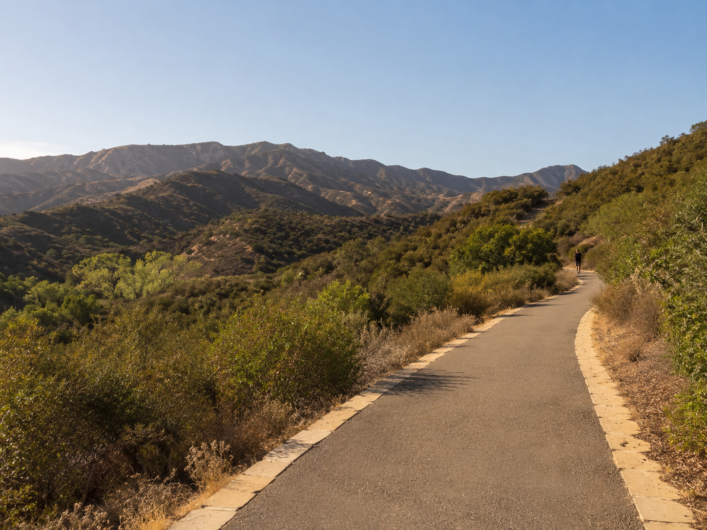 Topanga State Park from a Woodland Hills 91364 access point — the 36,000-acre wilderness that begins where Woodland Hills's western residential streets end. For residents of the canyon-adjacent sub-neighborhoods, this park is not a weekend destination requiring a drive — it is a morning walk, an after-work trail run, or a Saturday hike that begins at the front door.
The primary Topanga State Park trails accessible from Woodland Hills 91364:
🥾 Eagle Rock Trail (moderate, 8.5 miles round trip):
- → One of the park's most rewarding and most popular routes — climbing to Eagle Rock, a massive sandstone formation at the park's ridgeline with 360-degree views spanning the San Fernando Valley, the Santa Monica Mountains, and on clear days the Pacific Ocean
- → Trailhead: Trippet Ranch day-use area off Topanga Canyon Boulevard — approximately 12–18 minutes from most 91364 residential streets
- → Difficulty: Moderate — approximately 1,200 feet of elevation gain, exposed ridgeline sections in summer heat require early departure
- → ✅ Best for: Experienced hikers, trail runners, and anyone seeking the specific summit-with-view experience that makes Topanga State Park specifically distinctive from the SFV's flatter park options
🥾 Musch Trail Loop (easy-moderate, 3.9 miles):
- → A gentler Topanga option following seasonal Topanga Creek through native oak woodland — the trail that introduces most Woodland Hills newcomers to the park's accessible side and that functions as a daily walk for many western 91364 residents
- → Trailhead: Trippet Ranch
- → Difficulty: Easy to moderate — minimal elevation gain, well-maintained, accessible to children and less experienced hikers
- → ✅ Best for: Families with children, daily walkers, and residents who want the wilderness immersion without significant elevation
🥾 Dead Horse Trail (moderate, 5.4 miles):
- → A loop connecting multiple park trail segments through the chaparral — popular for trail running and mountain biking as well as hiking
- → Access: Trippet Ranch or Topanga Canyon Boulevard trailheads
- → ✅ Best for: Trail runners and mountain bikers seeking a multi-use loop
🥾 Santa Ynez Canyon Trail (moderate, 3.7 miles):
- → Follows Santa Ynez Creek through a canyon with intermittent waterfalls in the wet season — the park's most dramatically different seasonal experience, with winter and spring visits producing creek crossings and waterfall presence that the summer chaparral landscape doesn't show
- → Trailhead: Pacific Palisades-adjacent — 25–30 minutes from 91364, but one of the park's most rewarding specific routes
- → ✅ Best seasonal use: November through April when the creek is running
Topanga State Park practical information:
- → 🌡️ Heat management: Topanga's exposed chaparral ridgelines reach 90–100°F+ in July and August afternoon temperatures. Plan departures before 8:00 AM in peak summer or hike exclusively in the shaded canyon trails during summer afternoons.
- → 🐍 Wildlife awareness: Rattlesnakes, mountain lions, bobcats, and coyotes are all present in Topanga State Park — awareness practices rather than concerns, but practices that visitors unfamiliar with wilderness hiking should research before their first visit
- → 🚗 Parking: Trippet Ranch day-use parking charges a fee ($12–$15 per vehicle); some trailheads accessible from residential streets have limited free roadside parking
- → 🐕 Dogs: Dogs are permitted on designated Topanga State Park trails on leash (6-foot maximum); verify the specific trail's dog policy before departure as regulations vary by trail section
2. 🌲 Santa Monica Mountains National Recreation Area — The Broader Wilderness System
Topanga State Park is one component of the 153,000-acre Santa Monica Mountains National Recreation Area — the federal designation that encompasses state parks, city parks, and protected open space from Woodland Hills 91364 to the Pacific Ocean. Understanding the full NRA as the backdrop to Topanga provides Woodland Hills residents with a more complete map of what is accessible from their neighborhood.
🏔️ The Backbone Trail (67 miles, end-to-end):
The Backbone Trail is the Santa Monica Mountains' long-distance through-route — running 67 miles from Will Rogers State Historic Park in Pacific Palisades to Pt. Mugu State Park at the Ventura County coast, passing through or near Woodland Hills's western boundary, Calabasas 91302, and the entire length of the range.
- → ✅ From Woodland Hills: The Backbone Trail's eastern sections near Topanga State Park are among the most accessible and most scenic — the Calabasas Peak section (covering the peak at 2,163 feet elevation, with views of the SFV, Malibu, and the Pacific) is reachable within 20–25 minutes from most 91364 residential streets
- → 📐 Day-hike segments: The Backbone Trail can be hiked in day-sections — the 6–12 mile segments between trailheads are the standard format for Woodland Hills residents accessing the trail system for day use
- → 🚵 Mountain biking: Portions of the Backbone Trail are designated multi-use and accommodate mountain biking — the Mulholland-adjacent sections near Woodland Hills are popular for longer mountain biking routes that exceed what the single-park trail systems provide
🦅 Malibu Creek State Park (10,000 acres, 10–18 minutes from 91364):
Malibu Creek State Park — accessible via Mulholland Highway from the Woodland Hills/Calabasas 91302 corridor — is the Santa Monica Mountains' most diverse and most recognizable state park, providing a completely different landscape character from Topanga's chaparral.
- → 🌊 Malibu Creek and Century Lake: The park's signature feature — a perennial creek feeding Century Lake, surrounded by volcanic rock formations that have served as backdrop for numerous television and film productions (MAS*H filming location, among others)
- → 🥾 Primary trails: The Crags Road trail (flat, paved, accessible — 3.5 miles to Century Lake), the High Road / Lookout Trail loop (moderate, panoramic views), and the Creek Road to MASH site trail (historical interest)
- → 🏕️ Camping: Malibu Creek State Park campground — the closest car-camping facility to Woodland Hills, 15–20 minutes from 91364 residential streets, with 60+ sites along the creek
- → 🎣 Fishing: Seasonal catch-and-release fishing in Malibu Creek for steelhead trout (in season)
- → ✅ Best for: Families with children (flat Crags Road, the rock formations at Century Lake, the creek for wading), film and history enthusiasts, and overnight camping
3. 🚵 Mountain Biking and Trail Running — Woodland Hills's Active Lifestyle Infrastructure
The Woodland Hills outdoor proposition for active lifestyle households — mountain bikers, trail runners, and endurance athletes — is among the strongest available from any residential address in the greater LA area, with a trail network density and quality that draws riders and runners from across Southern California specifically because of the Woodland Hills-accessible trailheads.
The mountain biking landscape:
- → 🚵 Calabasas Peak and the Saddle Peak trail system: Accessible from Mulholland Highway near the Woodland Hills/Calabasas 91302 boundary — one of the most popular and most technically varied mountain biking areas in Southern California, with routes ranging from beginner-appropriate fireroad climbs to expert-level single-track descents. The summit of Calabasas Peak (2,163 feet) provides the specific elevation and descent variety that makes this system a destination for mountain bikers from across the LA area.
- → 🚵 Backbone Trail sections: The Mulholland-adjacent Backbone Trail sections accessible from western Woodland Hills are multi-use trails that accommodate mountain biking — providing longer-distance route options for riders who want sustained distance rather than short loops
- → 🚵 Fire road access: The Santa Monica Mountains' extensive fire road network — accessible through the NRA's multiple trailheads near Woodland Hills — provides the specific wide-corridor, high-mileage riding that road bike transfers and gravel cyclists also use
The trail running community:
Woodland Hills has a specific and active trail running community that uses the Topanga State Park and Santa Monica Mountains trail network for everything from morning training runs to ultra-marathon distance routes. Key characteristics:
- → 🏃 Training specificity: The 1,200–2,000+ foot elevation gain available in the park's ridge routes provides the specific vertical training stimulus that road running cannot — a meaningful advantage for competitive runners who use the proximity for performance training
- → 🏃 The Topanga Trail Race: An annual trail race held within or adjacent to Topanga State Park that draws competitors from across Southern California — the event that most visibly demonstrates the regional significance of the trail running community centered around Woodland Hills and the park
- → ✅ Accessible entry routes: The Musch Trail and Dead Horse Trail loop provide accessible entry-level trail running routes (under 5 miles, moderate elevation) before residents progress to the park's more demanding ridge routes
4. 🌳 Urban Parks and Recreational Facilities — The Complete Woodland Hills Park Picture
Beyond the wilderness assets that define western Woodland Hills 91364's outdoor proposition, the neighborhood's urban park infrastructure serves the daily recreational needs of families with young children, fitness-focused adults who prefer structured facilities over trail environments, and community members who want organized sports and programming without a 20-minute drive.
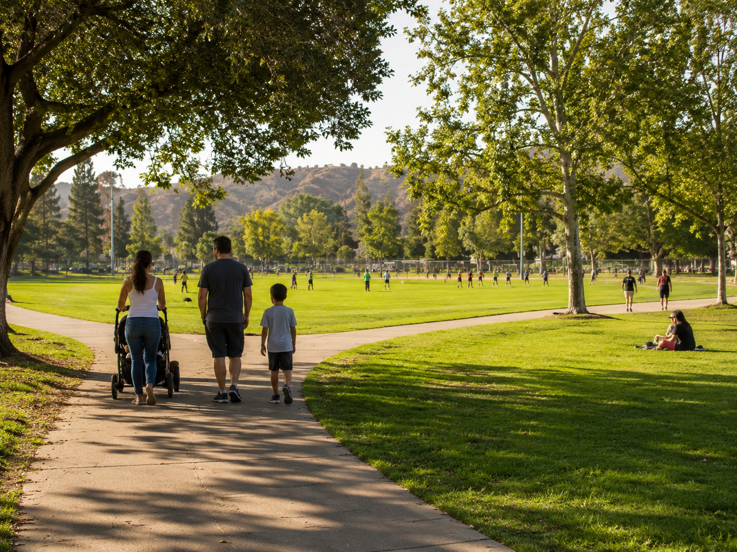 Warner Center Park in Woodland Hills 91367 — the neighborhood's primary urban recreational facility, providing sports fields, shade infrastructure, and the structured community park amenities that the daily recreation needs of flatland Woodland Hills families require without the wilderness access drive. For residents of the commercial-corridor 91367 addresses, this park is the primary local outdoor recreational asset.
🌳 Warner Center Park (91367):
- → Location: Warner Center district, Woodland Hills 91367 — the central community park serving the flatland commercial-residential corridor
- → 📐 Facilities: Multi-use sports fields for soccer, football, and baseball; fitness trail with exercise stations; picnic areas with shade structures; children's playground; restrooms
- → 👶 Best for: Families with young children, organized youth sports leagues, casual outdoor recreation without wilderness access
- → ⏰ Daily use pattern: Weekend mornings are the most active — youth soccer and baseball leagues, family picnic groups, dog walkers using the perimeter path
🌳 Serrania Park (91364):
- → Location: Southern Woodland Hills 91364, approaching the Calabasas/Woodland Hills boundary
- → 📐 Facilities: Smaller neighborhood park with picnic areas, playground, and informal open space — the local gathering point for adjacent residential neighborhoods
- → ✅ Best for: Immediate neighborhood use — families with young children in the adjacent residential streets, dog walking, casual picnic use
- → 🌿 Character: More intimate neighborhood park than Warner Center — the scale appropriate to its residential neighborhood setting rather than a regional destination
🏊 Woodland Hills Recreation Center:
- → City of Los Angeles-operated recreation center providing structured programming, gymnasium, and seasonal aquatics
- → 📋 Programs: Youth sports leagues, fitness classes, after-school programming, senior activities — the structured programming infrastructure that complements the unstructured wilderness access of the adjacent parks
- → 💰 Access: Los Angeles Parks and Recreation membership and class fee structure — verify current programming and fees at laparks.org
⛳ Woodland Hills Country Club:
- → 18-hole private golf course in Woodland Hills — one of the SFV's established private clubs with full golf, tennis, swimming, and dining membership amenities
- → 💰 Access: Private membership required
- → ✅ Best for: Golf-focused households for whom country club amenity access is a primary lifestyle consideration in the Woodland Hills purchase decision
🌊 Calabasas Lake:
- → A small private lake community adjacent to the Woodland Hills/Calabasas 91302 boundary — accessible to Calabasas Lake community residents for fishing, kayaking, and lakeside recreational use
- → ✅ Best for: Residents of the specific Calabasas Lake community; not a public access facility
5. 🐎 Equestrian Trails, Wildlife Watching, and Specialized Outdoor Experiences
Woodland Hills's proximity to the Santa Monica Mountains produces a set of specialized outdoor experiences — equestrian trail access, wildlife watching, and seasonal natural phenomena — that are unavailable from any other comparable urban-adjacent residential market in the greater Los Angeles area.
🐎 Upper Las Virgenes Canyon Open Space Preserve (equestrian):
The Upper Las Virgenes Canyon Open Space Preserve — accessible from western Woodland Hills 91364 and Calabasas 91302 — is the most significant equestrian resource in the western SFV, providing 4,000+ acres of preserved open space with an extensive trail network specifically designed and maintained for equestrian use.
- → 📐 Trail network: 15+ miles of equestrian trails through the canyon and grassland environment
- → 🐎 Equestrian facilities: The preserve accommodates both trailer-based access (horse trailer parking at trailhead) and direct trail access from adjacent equestrian properties
- → 🦅 Wildlife: The preserve's grassland and riparian habitat supports significant wildlife viewing — raptors including red-tailed hawks and golden eagles, coyotes, mule deer, and seasonal wildflower displays in the wet season
- → ✅ Best for: Equestrian households, hikers seeking lower-traffic trail alternatives to Topanga, and wildlife enthusiasts who prefer the open grassland character over Topanga's chaparral
🦅 Wildlife Watching:
The Santa Monica Mountains ecosystem adjacent to Woodland Hills supports a wildlife community that is genuinely extraordinary for an urban area — and that Woodland Hills residents experience as part of their daily life rather than as a special trip.
- → 🦁 Mountain lions: The P-22 mountain lion — famous for crossing the 405 and living in Griffith Park — brought national attention to the connectivity of the Santa Monica Mountains mountain lion population. This population regularly uses the Woodland Hills-adjacent protected lands as core habitat. Mountain lion sightings are rare but documented from Topanga State Park and the adjacent NRA lands.
- → 🦌 Mule deer: Regular presence throughout Topanga State Park and the adjacent protected lands — visible most frequently at dawn and dusk, often grazing at park boundaries adjacent to residential areas
- → 🦅 Raptors: Red-tailed hawks, Cooper's hawks, American kestrels, and occasional golden eagle and peregrine falcon sightings are common throughout the year. The thermal-generating ridgelines of the Santa Monica Mountains produce the specific updraft conditions that raptors use for thermal soaring — visible from hilltop positions throughout western Woodland Hills
- → 🐦 Birding: The Santa Monica Mountains National Recreation Area records over 450 bird species — the full diversity of Pacific Flyway migrants plus resident breeding species of the chaparral, oak woodland, and riparian environments. The seasonal peak for birding diversity: spring migration (March–May) and fall migration (August–October)
🌸 Seasonal natural phenomena:
- → 🌺 Wildflower season (February–April): The Santa Monica Mountains chaparral produces significant wildflower displays in wet years — Topanga State Park's grassland areas and the Backbone Trail ridgelines are among the best wildflower viewing locations accessible from Woodland Hills. After significant rainfall years, the displays rival those of the more famous Antelope Valley Poppy Reserve.
- → 🌊 Waterfall season (December–March): After significant rainfall, the canyon waterfalls in Topanga and Malibu Creek state parks activate — producing specific landscape experiences available only in the wet season. Santa Ynez Canyon's waterfall is the most accessible major waterfall from Woodland Hills.
- → 🎨 Fall color (October–November): The native big-leaf maple and valley oak in the canyon riparian areas produce genuine fall color change — not the dramatic autumn of the eastern United States, but a specific and beautiful seasonal transformation visible in the park's canyon bottoms
🚫 What NOT to Overdo
Don't attempt Topanga's exposed ridgeline trails in summer afternoon heat without preparation. The Eagle Rock and Backbone Trail ridgeline sections of Topanga State Park reach 95–105°F in July and August afternoons on exposed south-facing slopes. Hikers who start at 10:00 AM for a 4-hour ridgeline hike have made the most consistently dangerous preparedness mistake in the Topanga trail environment. Plan summit-route hikes with a 6:00–7:00 AM trailhead departure in summer; carry minimum 2 liters of water per person; know the location of park emergency contacts before departure. The beauty of the Topanga ridgeline is accessible year-round — summer access is early-morning-only access.
Don't treat the mountain biking or trail running access as equivalent across all Woodland Hills addresses. The trail access that makes western Woodland Hills 91364 canyon-adjacent addresses genuinely extraordinary is concentrated in the sub-neighborhoods closest to the park boundaries. Residents in eastern Woodland Hills 91367 or in the Warner Center commercial corridor are 20–30 minutes from the trailheads — meaningfully farther than the western 91364 residents who can walk to them. Buyers evaluating Woodland Hills specifically for the outdoor access should confirm the specific trailhead walking or driving distance from any target address before treating the neighborhood's outdoor proposition as uniform.
Don't rely solely on Topanga State Park for family outdoor recreation with very young children. Topanga's trail system — while extraordinary — is better suited to children who can maintain a moderate hiking pace for 2–4 hours than to families with toddlers and infants whose outdoor needs are better served by the structured, accessible park infrastructure of Warner Center Park 91367 or Serrania Park 91364. The Musch Trail at Trippet Ranch is the most family-accessible Topanga option for younger children — but it is still a natural trail environment rather than a developed playground facility.
Don't underestimate the fire risk context of the Santa Monica Mountains. The terrain that produces Topanga State Park's extraordinary beauty is chaparral — the specific California plant community that is highly adapted to fire and that produces the periodic wildfire events that have shaped the Santa Monica Mountains landscape for thousands of years. Woodland Hills residents whose properties are adjacent to this landscape should understand the fire risk framework (VHFHSZ designation for specific addresses), maintain defensible space per Cal Fire guidelines, and have evacuation planning established before fire season (June–November). The fire risk is a known, manageable characteristic of this specific landscape — not an emergency to be discovered without preparation.
Don't miss the seasonal variation. Woodland Hills residents who only experience Topanga State Park in summer are experiencing the harshest and most challenging season for trail use. The park's most rewarding periods are October through early June — when temperatures are comfortable for full-day hiking, the chaparral is alive rather than dormant, the creeks are flowing after winter rains, and the wildlife activity is highest. Residents who build the park into their year-round outdoor routine rather than treating it as a summer destination consistently find it more accessible and more rewarding than the summer-only visitor.
🏠 Real-World Scenario — Woodland Hills 91364
A family that had relocated from Denver, Colorado — two parents who had been avid mountain hikers throughout their adult lives, two teenage children who had grown up trail running — purchased a home in western Woodland Hills 91364 specifically for the outdoor access. They had researched LA outdoor options extensively before deciding on Woodland Hills: the beach communities had the ocean but no mountain terrain; Pasadena had the San Gabriel Mountains but significantly worse summer air quality; Studio City and Sherman Oaks had the urban lifestyle but no wilderness adjacency.
Their first full weekend in Woodland Hills 91364: the family walked from their front door to the nearest Topanga State Park trailhead — 22 minutes on foot. They hiked the Musch Trail loop as an orientation tour, then connected to the ridge route toward Eagle Rock. At Eagle Rock, the father stood looking at the Pacific Ocean visible to the south and the San Fernando Valley visible to the north and said: "This is 22 minutes from our front door."
Within six months, their established weekly pattern: Tuesday and Thursday morning runs (the mother and older teenager using the Dead Horse Trail loop at 6:30 AM before work and school), Saturday family hike (varying the route weekly — Eagle Rock, Calabasas Peak, sections of the Backbone Trail), and Sunday morning bike rides on the Mulholland-adjacent fire roads (the father and younger teenager on mountain bikes).
The comparison they consistently made to their Denver outdoor lifestyle: "In Denver we drove 45 minutes to the trailhead for comparable terrain. Here we walk. The access is genuinely better than what we had in Colorado — and we moved here from the outdoor capital of the United States."
Two years post-move: they have hiked every major Topanga route, completed a full day of the Backbone Trail in segments, and encountered mule deer on a Tuesday morning run more times than they can count. They describe the outdoor access as the feature of Woodland Hills that most exceeded their pre-move expectations — which, given that it was their primary purchase motivation, is a meaningful assessment.
🏠 Real-World Scenario — Woodland Hills 91364
A single professional — a wildlife biologist working for a Los Angeles County conservation organization — had been searching for an LA address that provided genuine daily wildlife access rather than the incidental wildlife that urban park greenbelts produce. Her professional life involved field work in the Santa Monica Mountains; she wanted her personal life to have the same quality of natural landscape access.
She had evaluated Malibu (too remote from her office and too expensive), Topanga Canyon (similarly remote with challenging road access), and multiple SFV neighborhoods before identifying western Woodland Hills 91364 as the specific combination of accessible urban infrastructure and wilderness adjacency that her life required.
Her primary outdoor use from her Woodland Hills 91364 home: dawn wildlife monitoring walks in the Topanga State Park boundary area — the transition zone between the residential edge and the park interior that produces the highest wildlife encounter frequency. In the first year from her Woodland Hills address, her wildlife encounter log from walks within 20 minutes of her home included: 14 mule deer sightings, 4 coyote sightings, 2 bobcat sightings, a mountain lion track set confirmed by a park ranger, and a recorded 68 bird species including a golden eagle and a prairie falcon.
She describes the Woodland Hills outdoor proposition not in the terms of a recreational amenity — trail length, elevation gain, facility quality — but in the terms of her professional domain: "The ecological connectivity between this neighborhood and the NRA is real. The wildlife doesn't recognize the residential boundary. I see species here that my colleagues drive an hour to study."
The Woodland Hills outdoor access that the luxury buyer's guide and value comparison articles document in real estate terms is, from a wildlife biologist's perspective, the documented presence of a functional, connected wilderness ecosystem at the edge of the Valley's most western residential neighborhoods. That ecological reality is what produces the morning mule deer and the Tuesday trail run coyote and the hawk that circles the parking lot at Trippet Ranch while families load their hiking boots.
❓ FAQ
What outdoor activities are available in Woodland Hills? Woodland Hills 91364 and 91367 offer one of the most diverse outdoor activity menus available from any LA residential neighborhood: ✓ Hiking — Topanga State Park, Malibu Creek State Park, and the Santa Monica Mountains National Recreation Area with 100+ miles of trail accessible within 20 minutes. ✓ Mountain biking — Calabasas Peak trail system, Backbone Trail multi-use sections, and Santa Monica Mountains fire road networks. ✓ Trail running — Topanga State Park trail system with routes from 3–15+ miles and 500–2,000+ feet of elevation gain. ✓ Equestrian — Upper Las Virgenes Canyon Open Space Preserve's 15+ miles of equestrian trails. ✓ Wildlife watching — mountain lions, mule deer, bobcats, 450+ bird species in the adjacent protected lands. ✓ Seasonal wildflowers, waterfalls, and fall color in the canyon environments. ✓ Urban parks — Warner Center Park, Serrania Park, and the Woodland Hills Recreation Center for structured recreational facilities.
Is Topanga State Park accessible from Woodland Hills? Yes — Topanga State Park is the most directly accessible major state park from Woodland Hills 91364, with trailheads reachable within 5–22 minutes from most 91364 addresses, and from some western canyon-adjacent residential streets by foot. The primary access point is Trippet Ranch off Topanga Canyon Boulevard — approximately 12–18 minutes from most Woodland Hills residential streets. The park encompasses 36,000+ acres with trails ranging from the accessible Musch Trail loop (3.9 miles, easy-moderate) to the Eagle Rock summit route (8.5 miles, moderate, 1,200 feet elevation gain). Parking at Trippet Ranch is fee-based ($12–$15/vehicle).
Can you hike from Woodland Hills to Malibu? Yes — through Topanga State Park and the Santa Monica Mountains National Recreation Area's connected trail system. The specific route most commonly used is a section of the Backbone Trail that traverses the Santa Monica Mountains ridge from the Woodland Hills/Topanga corridor to Malibu Creek State Park and ultimately to the Pacific Ocean. The full continuous route from the Woodland Hills-adjacent trailheads to the coast is approximately 30–40 miles depending on the specific entry and exit points — a multi-day backpacking route or a long day hike in stages. Day hikers typically complete the Woodland Hills-accessible sections to Calabasas Peak, Eagle Rock, or the Topanga-Malibu Creek connector and return to the trailhead.
What wildlife can you see near Woodland Hills? The Santa Monica Mountains NRA adjacent to Woodland Hills supports: ✓ Mountain lions (rare sightings in the protected lands). ✓ Mule deer (regular sightings, especially dawn and dusk). ✓ Bobcats (occasional sightings on trail). ✓ Coyotes (common, both in the park and in adjacent residential areas). ✓ 450+ bird species including raptors (red-tailed hawks, Cooper's hawks, golden eagles seasonally, peregrine falcon). ✓ Western rattlesnakes (present throughout the chaparral — hikers should exercise standard caution). ✓ Native reptiles including western fence lizards and California kingsnakes. The wildlife diversity reflects the ecological connectivity of the Santa Monica Mountains ecosystem — one of the most intact urban wildlife corridors in the United States.
Are there bike trails in Woodland Hills? Yes — Woodland Hills 91364 provides access to some of Southern California's most sought-after mountain biking terrain. The Calabasas Peak trail system (accessible from Mulholland Highway, 15–20 minutes from most 91364 addresses) is a regional mountain biking destination with routes from beginner fireroad climbs to expert single-track. Backbone Trail sections near Woodland Hills are designated multi-use and accommodate mountain biking. The Santa Monica Mountains fire road network provides extended mileage for riders seeking longer-distance routes. Within Woodland Hills itself, the flat streets of 91367's Warner Center corridor provide road biking circulation, and the Ventura Boulevard bike lane runs through portions of the neighborhood.
What is the best park in Woodland Hills for families? For families with young children: Warner Center Park (91367) provides the most accessible, structured park experience with playgrounds, sports fields, shade, and restrooms — the daily-use family park that serves the flatland residential community. For families with older children and teenagers who can hike moderate distances: Topanga State Park's Musch Trail loop (3.9 miles, Trippet Ranch) is the most accessible wilderness introduction from Woodland Hills — beautiful, varied, and manageable for most family hiking groups. For a day combining both — a morning Musch Trail hike followed by afternoon Warner Center Park time — Woodland Hills delivers a family outdoor day that no single-park alternative in the SFV replicates.
🎯 Bottom Line
The outdoor landscape accessible from Woodland Hills 91364 and 91367 is the defining feature of the neighborhood's residential proposition — and it is specifically irreplaceable. No other SFV neighborhood at any price point provides front-door access to 36,000 acres of state park wilderness, 153,000 acres of national recreation area, the Backbone Trail, Malibu Creek State Park, and the Upper Las Virgenes Canyon equestrian preserve simultaneously. The outdoor access that buyers from Colorado, the Pacific Northwest, and Northern California move to Woodland Hills specifically to find is not a marketing claim — it is a topographical reality produced by Woodland Hills's position at the exact edge where the San Fernando Valley meets the Santa Monica Mountains.
For residents who build this access into their daily routine — the Tuesday morning trail run, the Saturday family hike to Eagle Rock, the Sunday mountain bike ride on the Calabasas Peak fireroads — the quality-of-life consequence is specific and cumulative. It is the mountain lion track in the mud at the park boundary. It is the golden eagle thermal-soaring above the ridge on a January morning. It is the Pacific Ocean visible from the summit after 1,200 feet of climbing that started at the end of your street.
Woodland Hills 91364's outdoor access is not an amenity comparable to a city pool or a community tennis court. It is wilderness — and Woodland Hills residents who engage with it fully are living within walking distance of a wilderness experience that most Angelenos will never have.
📩 Want to Find a Woodland Hills Home With the Best Outdoor Access for Your Lifestyle?
Whether you're a trail runner evaluating trailhead walking distance, a mountain biker researching Calabasas Peak access, or a family looking for the right balance of wilderness adjacency and urban amenities — we'll help you identify the specific Woodland Hills 91364 sub-neighborhoods where your outdoor priorities are best served.
Contact Liana Shersher at Parkway Estate Properties: 📧 liana@parkwayestate.com · 📞 (818) 208-5881 · 🌐 parkwayestate.com 15021 Ventura Blvd., Ste. 510, Sherman Oaks, CA 91403
About the Authors
Liana Shersher is a licensed real estate agent with Parkway Estate Properties Inc. and an Accredited Buyer's Representative (ABR) serving the San Fernando Valley — with a focus on Sherman Oaks, Encino, Tarzana, Woodland Hills, and Northridge (DRE# 02164224). Liana guides first-time homebuyers through every step of the purchase, from the first showing to the keys in hand, and represents move-up and repeat buyers across the Valley. For sellers, she builds the pricing and marketing strategy that positions a home to sell for top dollar, fast. Buyers and sellers work with Liana for clear communication, sharp local knowledge, and an agent who treats their goals like her own.
Roman Shersher is the broker-owner of Parkway Estate Properties Inc. and a real estate investor with 18 years of experience in the San Fernando Valley (DRE# 01855095). Roman has personally led or co-led renovations on dozens of properties across the Valley, including recent projects in Northridge (91324) and Woodland Hills (91364). That hands-on renovation and investment experience shapes every pricing conversation and days-on-market strategy at Parkway — sellers get a realistic read on what improvements actually return at resale, and buyers get an expert eye on a home's true condition and upside.
Parkway Estate Properties, Inc. · 15021 Ventura Blvd., Ste. 510, Sherman Oaks, CA 91403 · (818) 208-5881 · parkwayestate.com · Broker License #: 01873092 Equal Housing Opportunity. Information herein is general and not legal, tax, or financial advice. Consult qualified professionals for your specific situation.
Categories
Recent Posts






Broker | Realtor ® License ID: 01873092
+1(818) 208-5881 | info@parkwayestate.com